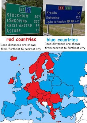
Imagine: You are traveling on an interstate highway. You approach one of those large blue or green signs that tell you how far ahead the upcoming cities and towns are.
What order are the names in, closest-to-farthest or farthest-to-closest?
[Spoiler ahead... think of your answer first.]
It seems natural to me that closest-to-farthest makes the most sense because I should see first the one that might be just about to happen, but I realize now, since the question has been asked, that maybe it just seems to make sense because it's how I've always seen it in the U.S.
And it turns out it's not always done this way. Here's how it's done in Europe, for instance:

I have no idea why some countries do their signs one way and some the other way, or why there is so much geographic coherence in the pattern. Do note, however, that the Balkans are balkanized, and Ireland thumbs its nose at Britain. Makes sense.
But I did find out the reason for the two white-colored countries (Bosnia and Kosovo): they don't have Google Street View, which was used to compile the data. Kosovo, reportedly, should be colored red. No info on Bosnia.
Source
Saturday, November 2, 2019
Fun Fact
Posted at
1:51 PM
![]()
![]()
Categories: Facts I Never Knew
Subscribe to:
Post Comments (Atom)


No comments:
Post a Comment